|
El Niño:
Unpredictable Christmas Child
"There's a good
chance 2002 will be an
El Niño-year". 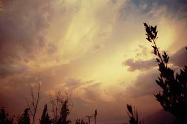
El Nino, a sudden shift of warm sea surface water, changes the normal
weather patterns
above the Pacific. And that turns over the weather around the
globe.
The Ocean researchers are alert: "there's something going on; something
El Niño-like" .
El Niño is as old as the world. The Inca's in Peru already
knew of this phenomenon, and built their cities upon the hills, far
away from the unpredictable water with its sudden flooding. Geologists
found 13000 year-old traces of El Niños in Peruvian coastal villages. Written reports of
El Nino effects in Peru go back to
1500.
But this Spanish "Christmas Child", was named "El
Nino" by Peruvian fishermen; at the end of the 19th century. They
discovered that once in odd
years around Christmas time, the anchovy and sardine's suddenly
vanished without trace.
The fish had moved; thousands miles to the south, to the Chilean coast,
where the sea water was colder -- and more abundant
in food that the warmer waters..
At the Peruvian and Ecuadorian coast, usually an Eldorado for
fishermen, an enormous pool of warm
water suddenly appeared, about 25 º C some 5
degrees warmer than normal.
The nets were empty, millions of seabirds and other animals
starved and
the guano-gatherers; earning a living by collecting nitrate-rich dirt
of cormorants, seagulls and penguins; searched in vain for this
lucrative stuff.
El Niño had taken control for a while.
El Niño and the Ocean's seesaw.
Warm
and cold ocean water don't mix easily: in fact that's the reason for
the existence of El Niño's. The dividing line between warm water layers
(about 25 º C)
and cold (15 º C
and lower) is a sharp one; called a thermocline. In the Western
Pacific; near Australia and Asia, this line lies far deeper that in the
Eastern Pacific;
near the Americas. The trade winds blows the warmer surface water to
the west;
it piles up there. On the other hand, at the Eastern Pacific
as the warm
water is blown away; colder water will replaces it. The thermocline through the Pacific does not lie horizontal.
It's deeper in the west and shallower in the east. It behaves like a
seesaw: with the movements of
ocean water; caused by currents and wind, it swings to and fro. That
swing is
very slow, for the ocean is incredible tardy. Its a process that takes
months'.
The thermocline through the Pacific does not lie horizontal.
It's deeper in the west and shallower in the east. It behaves like a
seesaw: with the movements of
ocean water; caused by currents and wind, it swings to and fro. That
swing is
very slow, for the ocean is incredible tardy. Its a process that takes
months'.
The
Ocean and the atmosphere
So the atmosphere and
the ocean
interact and influence each other. The trade
winds also cause a change in temperature difference between the west
and the
east of the Pacific. Air rises more above warm water than
above cold
water. If the air rises and becomes colder as it enters higher
altitudes, the
water vapour in the air condenses and it rains: that is why in the
Pacific it
rains much more over the warm west near Asia than over the cold east
near Peru
and Ecuador. Also, the rising air in the west sucks in more air, and
this is
partly responsible for the strength of the trade winds.
If, for one reason of
another, the trade winds
slacken, it will cause the east to be less cold and the temperature
difference
between east and west will diminish. And if the difference in
temperature
lessens, the trade winds will lose strength. In this way there is a
kind of
circle of causes and effects that can reinforce each other: weaker
trade winds give a
smaller temperature difference, this gives weaker trade winds and so on.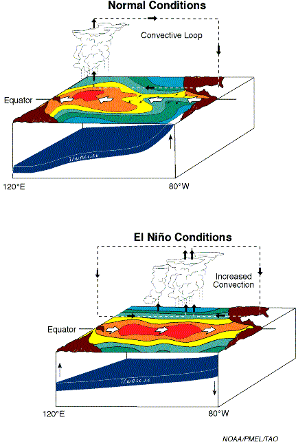
Weaker trade winds means that less warm water is blown to the western
Pacific;
the thermocline will rise in the West. The warm water moves inchmeal to
the
east; the coast of America gets slowly but surely a thicker layer of
warm water.
This warm layer pushes the cold water to the deep; the thermocline
sinks.
And what's more: the thermocline dips often to
the other side; - sinking in the east and rising in the west: its a
self
consolidating process. The thicker warm water layer in the east causes
higher
temperatures of the air above. This air has the tendency to rise -- and
sucks in
more air to the Eastern Pacific -- the opposite direction of the normal
trade
winds. Sometimes this is so strong that the trade winds will ease
totally or
reverse. -- and as that trade winds were responsible for moving the
warm water
to the western pacific -- the thermocline in the west will rise more
and more
El Niño is born: thanks to the seesaw of the Ocean.
The end of El Niño
The working of this seesaw also causes El Niño's end -- or
even the opposite
situation La Nina.
The
deviations in the trade winds - caused by the
higher-than-normal surface temperatures - are most strong in the middle
of the
Pacific Ocean, around the date line (longitude 180º ). The thermocline
will also
be deeper at that place as it is in the Eastern Pacific.
And this brings an El Niño to its end. All this warm water in the east,
caused
by the winds around the date line, must come from somewhere, and that
is from
regions a little north and south of the equator. 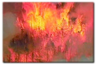
The thermocline will rise in those off-equatorial regions. Its like a
waterbed:
when you push the water down at one place it'll rise
somewhere. The
shallow parts in the thermocline can move back to the equator.
Probably,
reflections of the shallow parts at the western coast are important for
this
process. On the contrary, the deep part in the east has a tendency to
move
poleward, leaving the region where it can influence El Niño
development.
Next, the shallow regions in the west travel eastward along the
equator, and
overcome the wind anomalies, and eventually the thermocline in the east
will rise again.
La Nina
While the ocean tries to find it normal balance; the thermocline in the
east can
rise above its normal level and a state develops which is known as La
Niña,
with colder than normal surface waters in the east, and stronger than
normal
trade winds. This mechanism, which consists of a quasi-instantaneous
positive
feedback, followed by a delayed negative feedback, is known as the
delayed
oscillator mechanism.
El Niño
and the weather around the globe
Everybody
will agree: El Niño is a
quite innocent name for such a phenomenon bringing trouble and disaster
for huge
parts of the world. Floods and heavy rain in South America's west coast
to
extreme drought and famine in Australia, India, Asia and Africa. Even
the
European weather is likely to be influenced by El Niño.
But meteorologists think that El Niño's
reputation is very blackened by the media -- and therefore by the
public --.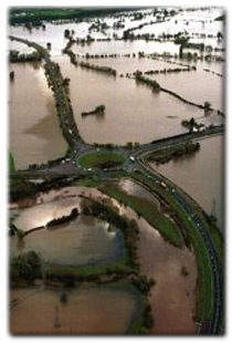 The phenomenon is almost a synonym for tornado's, hurricanes,
downpours, floods, extreme droughts, abortive harvests and
forest-fires. After almost every natural disaster the media
blame it on El Niño -- even when it hasn't been an
El Niño year at all -- and when it isn't El Niño;
its the greenhouse-effect or global warming. Nonsense of course, El
Niño
is a natural phenomenon, it belongs to the earth and atmosphere. It
isn't good
or evil".
The phenomenon is almost a synonym for tornado's, hurricanes,
downpours, floods, extreme droughts, abortive harvests and
forest-fires. After almost every natural disaster the media
blame it on El Niño -- even when it hasn't been an
El Niño year at all -- and when it isn't El Niño;
its the greenhouse-effect or global warming. Nonsense of course, El
Niño
is a natural phenomenon, it belongs to the earth and atmosphere. It
isn't good
or evil".
However during an El Niño Indonesia, the Philippines, Middle and South
America's west coast are in severe danger. Due to the last El Niño
Indonesia suffered a terrible famine and enormous forest-fires, which
set up the
whole area in a thick layer of smoke for months. Many floods and
landslides in
Middle America brought disaster and drew the attention of the whole
world.
Positive
effects.
But
El Niño also has positive
effects; especially in North America.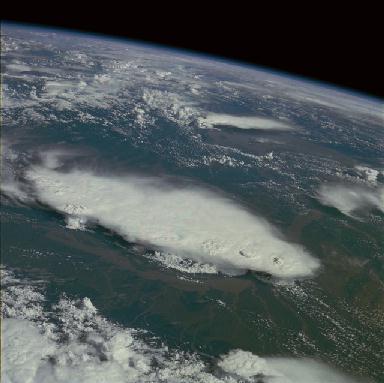 There are less hurricanes on the
Atlantic
and tornado's in the US. The North East of America
is warmer than normal -- so less to burn -- for the polar jet stream
can't get
very far south during an El Niño. There are less hurricanes on the
Atlantic
and tornado's in the US. The North East of America
is warmer than normal -- so less to burn -- for the polar jet stream
can't get
very far south during an El Niño.
California has more rain than normal, but it falls more equal - like
real British
drizzle - so there's not so much damage to the road. The Californian
fishermen
catch suddenly the most exotic tropical fish, in marvellous colours --
normally
these fish do not come so far north.
El Niño
and the research
As
El Niño brings so much trouble and
disaster throughout the world; it'll be a good thing that an El Niño
can be forecasted and eventually measures can be taken. And for
oceanographers
and meteorologists El Niño is a really
fascinating phenomenon.
'It influences the worlds' weather in a striking organized order. But
we do not
understand the whole phenomenon properly. The ocean is slow, very dim.
but it
sure moves. The so-called Kelvin- and Rossby-waves - which somehow play
a role
in the El Niño development - move about 2
meters a second. You easily could walk with such a wave. The water
moves,
although very tardy - but it does - you can't stop an El
Niño".
Concerning
speed the ocean may move at human pace; the amounts of water which is
travelling
across the Pacific; set going by El Niño,
goes beyond every imagination. "Within five to ten years we'll know
more.
Hopefully at that time we'll have climate-models that can predict
better and
more exactly.
The
Oceans' buoys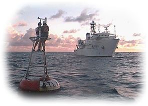
All eyes are
upon 70 TAO-buoys laid down in the Pacific Ocean. TAO stand for
Tropical
Atmosphere Ocean. They are posted since the eighties along the equator
as the
worlds first warning system for disruptions in the tropical ocean. They
make
daily measurements of water temperature - to 500 meter depth
- the
pressure and humidity. These data are sent via a satellite-system to
the Pacific
Marine Environmental Laboratory in Seattle; and to other
research-institutes
throughout the US, Europe and Japan. "We have a good three-dimensional
view
of the ocean. The system is expensive and complicated a costs over a
hundred
million dollars a year for maintenance. But its worth it: we know much
more
about the El Niño-movements and every step
brings us closer" .
The
El Niño indices
How strong is
an El Niño? You can measure it in two ways: The
Niño-3 index and the Southern Oscillation Index.
The one most used for the El Niño force is
the Niño-3 index. It measures the water temperature in the Eastern
Pacific (
the area between - 5º
and + 5 º
latitude and - 150º
and 90º
longitude). The Niño-3 index
swings between - 2
º
C and + 4º C; mostly between + 1º C and - 1º C. During a
heavy El Niño
the sea water temperature can have a variation of 5 - 8 º
C.
Except the warmer-than-normal sea water, there also is a
lower-than-normal
difference in air pressure between Tahiti and Darwin (Australia) during
an El Niño.
This difference in pressure is called the Southern Oscillation Index,
swinging between - 3 and + 3. The Southern Oscillation (southern swing; term
from Sir
Gilbert Walker, an English meteorologist during the 1920's) is the
change of
pressure above the Pacific and the variation in the trade winds that's
connected
with it.
between - 3 and + 3. The Southern Oscillation (southern swing; term
from Sir
Gilbert Walker, an English meteorologist during the 1920's) is the
change of
pressure above the Pacific and the variation in the trade winds that's
connected
with it.
El
Niño and the
Southern Oscillation
(ENSO) are the main authors of the climate changes across the globe.
Want to know
more?
There are
various El
Niño-sites on the
web; here
are a few to help you on the way
http://www.elnino.noaa.gov/
http://www.pmel.noaa.gov/tao/elnino/nino-home.html
http://www.pmel.noaa.gov/tao/jsdisplay/
http://www.ecmwf.int/products/forecasts/seasonal/
Illustrations:
NOAA/ENSO/KNMI
web-sites
Quotations from interviews with G.J. van Oldenborgh and G.
Burgers;
oceanography KNMI.
By Wijke Ruiter
wijke@scribeweekly.com
|