| Scribe Weekly |

|
|
Dedications for Scribe Weekly Radio
|
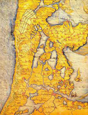
New land BY Wijke Ruiter Holland Hand a Dutchman a
spade and he’ll start building dikes and digging canals. He simply
can’t help it: its in the blood. Take a quick look at a 17th
century map of Holland and compare it to the modern one you know: the
big patchwork of land, wetlands, swamps, lakes and estuaries is
reshaped into fixed constructed polders: New Land all over Holland. The
Dutch had to: two-thirds of the country is below sea level. History
tells of a long sequence of flash floods and disaster; no one can live
with that! An
endless fight against the sea and a untameable urge to extract land
from it: the winner takes it all. Why would you want to live in a
place like that? Since many, many
centuries people have lived on the spot in Europe that we now call the
Netherlands. It was a nameless swamp then, but there was plenty of fish
and small wild to hunt. The first people built little villages on the
higher area’s along the rivers. The land was fruitful,
obviously fertile enough to counterbalance the continuous
threat of flash floods which regularly harassed the tide-woods along
the North sea-coast. Later the early Dutch
started to built high hills to live on; and at the start of the era
these area’s where the most densely populated and the prosperous of all
Western Europe. However the Romans thought the early Dutch were
barbarians, they surely were astonished by what they found: the first signs of dikes, hills and canals;
just to keep the land (and the feet!) dry. Growth, cry for freedom and
windmills Ask
someone about Holland and at least he’ll mention Amsterdam, tulips,
wooden shoes and windmills. These mills were invented in the
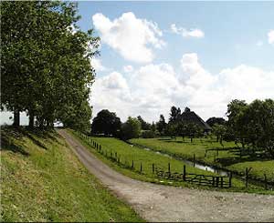
early Middle Ages and developed further to drive paddle-wheels. Around that time the
first polders grew; people started to build dikes around pieces of
reclaimed land to keep it dry. This land mainly existed of peat-land;
and the peat was extracted from it. But the land lowers when it’s
drying and the new polders were under constant threat from flood rain
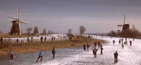
and seeping water. The windmills were of great importance; they paddled
the water out of the polders with their huge wheels. Slowly the typical
Dutch polder-landscape developed, with thousands of windmills along
dikes to keep the lowlands dry. The big innovation was a
windmill with a revolving top. It could turn in any wind direction; the
possibility to dry little lakes was achievable and with an
ingenious system of two or three mills in a row
you could dry deeper lakes. Those former lakes;
which are dry land now, are called “droogmakerijen”. The most famous
one is the Beemster. A famous achievement at the time; famous engineers
from Britain and Italy came over to have a look. Its one of the
Unesco’s world inheritance sites.
In the 17th century Holland was one of the most
powerful countries in the world. And Amsterdam was a very influential
city. But the city of
Amsterdam, with its surrounding grounds, was threatened by a huge lake
on one side and a huge Inner sea; the Zuiderzee, on the other. Plans
were made to reclaim these waters too. But the windmills didn’t provide
enough power for such a huge undertaking. De Zuiderzee-polders It
would take two centuries before new plans were made. The engineer was Cornelis Lely (1854 – 1929).
His name will always go with the huge project of the reclamation of the
Zuiderzee. De
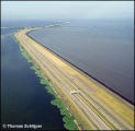
Afsluitdijk De Afsluitdijk (literally: closing dike) was
the most important projects of them all. It had to succeed and it did,
however the first world war almost spoiled the game.
In that time many engineers were convinced it wasn’t
possible; but the advantage was clear; the Dutch vulnerable coast-line
would be considerably shortened. The building of this
dike, mainly by hand, was started in 1920; at first with a smaller part
of 8 miles, and finished finally in 1932. The dike is 20 miles long, at
the waterline 300 feet wide and 30 feet high (above sea level). The construction of the
Afsluitdijk cost 120 million gilders; a monstrous amount of money in
that time. Maybe worth mentioning are the
defence works along this dike. Of course, so thought of Secretary of
Defence, this dike should be protected against assaults of eventual
enemy’s. Everywhere along the dike you can find them:
the so-called “kazematten” (literally “soldiers
places”). The 10th of May 1940 Germany
invaded Holland. And the “kazematten”of the Afsluitdijk showed their
value; everywhere in Holland the Germans broke through except for the
Afsluitdijk! The first polder: De Wieringermeer. The very first polder
was reclaimed during the 1930’s. Before the Second World War the land
was ready for agriculture and many farmers started a living. Just
before the end of the The
second polder: Noordoostpolder. Two former islands are received
into the landscape. One of them –Schokland – is a monument of the
Unesco’s World Inheritance. It’s a lovely place to be and certainly
worth visiting. Schokland certainly is still an island, its has
everything that reminds you of the surrounding water, except for the
fact that it’s missing. The harbour with its jetties are there, as a
silent monument in the landscape. There’s a museum in the former church
of Schokland. Missing
water With the construction of the
Noordoostpolder one big failure became very clear; the polder was
situated directly next to the “old” land; with huge consequences for
the water-household. The level of the groundwater in the ‘old’ region
lowered immediately and the old land –mainly peat-moor- started to set. To keep the groundwater at
acceptable level; another pump-system was needed.
So the solution came quickly:
the next two polders have a so-called “randmeer” (literally
margin-lake). It’s a piece of water between the ‘old’ land and the
polder. No problem with the groundwater anymore; and this “randmeer” is
lovely for all kinds of marine sports; not to forget a marvellous place
to skate in wintertime, when all that water is frozen. The
third polder: Oostelijk Flevoland February 2nd 1953 an
enormous disaster took place in the southwest of Holland, this part of
the country flooded due to a hurricane.
All the material that could be used to restore the
damage was needed in that region. So the building of the Flevopolder
dike was delayed for about a year. But in September 1956 the first
piece of the Flevopolder-dike was closed. It took 9 months of
continuous pumping before the polder was dry: June 29 1957. It took
about 12 years before the first farms were built and around 1972, all
the nowadays villages of that part of Flevoland were established.
The
last polder: Zuidelijk Flevoland Zuidelijk
Flevoland was dry at May 28 1968.
The
pumping stations needed almost 7 months to get all the water out. The
first farms arose in 1979.This polder has some striking details: the
huge area’s of agriculture are surrounded by a big forest at the east
side Horsterwold (4000 ha), a planned city for 300.000 people (Almere),
and an unplanned, but lovely, nature reserve: the wetlands at the
eastside, next to the IJsselmeer. It’s become one of the most important
wetlands of Europe: de Oostvaardersplassen.
This nature reserve developed spontaneously; it
simply was to deep to get all the water out: and huge amounts of birds
–in all species; the rare brown and white harrier, grey goose,
cormorant, spoonbills, great white heron and the little egret prefer to
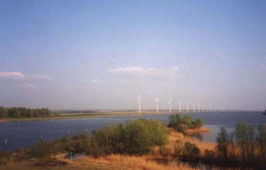
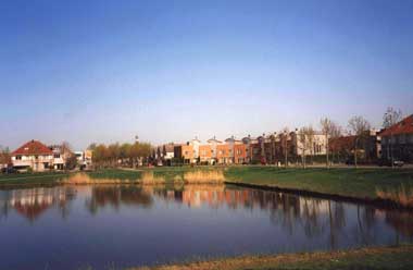
live there! With the birds other animals came; ermines, At the eastside of
this polder, situated to the randmeer-piece called Wolderwijd, is a
small village called Zeewolde. It has about 15.000 inhabitants. This
village, is not only meant as service for the surrounding farms but
also attractive as area for recreation. Thanks to its situation it’s
interesting for water sports enthusiast. The
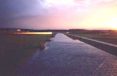
reclaiming and structuring of a polder When the land is
pumped dry; the whole place is very inaccessible. The soil is still
very wet and muddy; it’s difficult, actually impossible to bring heavy
machines into the area. So
the first routes for access are big canal already dug under water
before the polder was pumped dry. Along that canal all the remaining
water can be pumped away by the stations. And over these canal heavy
machines can be brought into the areas, but by water rather than land.
The first roads can be constructed and finally when the land is dry
enough, the soil can be cultivated. It means hundreds of miles of
canals, ditches and drains. Above as well as in the ground; drains
everywhere. In this article I wanted to
tell you about another side of Holland. Of course Amsterdam is famous
for its canals, trams, buildings and drug policy. But The Netherlands
have much more to offer for the one who wants to find it. And the
construction of new land – surely also and typical Dutch phenomenon –
is one of them. with
many thanks to: the museum new land, Lelystad
|
 Second
World War (April 17 1945) the Germans bombed the dikes and the polder
flooded. It was a pure action of aggression; no need to do that. Many
lives were lost though,
Second
World War (April 17 1945) the Germans bombed the dikes and the polder
flooded. It was a pure action of aggression; no need to do that. Many
lives were lost though,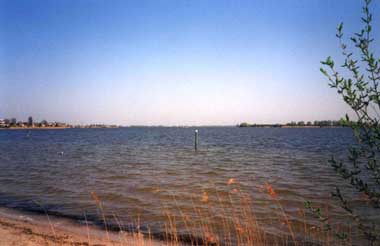
 martens,
otters, foxes and deer.
martens,
otters, foxes and deer.