| April – May Weather Special |
||||
| Weather specials |
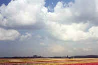
Spring
showers. BY Wijke Ruiter Cumulus clouds look like lumps of cotton wool.
They are formed as the sun heats up the ground that in turn the air
right above. When air
is heated it will expand and becomes less dense than the
surrounding air. Warmer air always rises. During
rising the air will cool down and condense; water vapour will turn into
tiny
water droplets and a cumulus cloud appears. Actually we see the bottom
of the
cloud. As long
as the air cloud stays warmer than its environment it will keep on
growing and
growing into the higher atmosphere. The temperature there is below
zero: the
clouds water droplets will turn into ice-crystals: and snow is born. The top
of the cloud gets the “anvil-shape”; cumulus has developed into
cumulonimbus
(nimbus = rain). At the top of a cumulonimbus
there’s always ice and
snow. On the
ground people run to find shelter; looking for an umbrella or simply
get wet: it
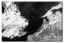
rains. Characteristic
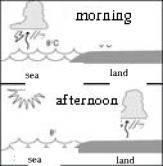
for springtime is the division of the showers above land and sea. The
water of the North Sea is considerably colder than the air above land.
So
cumulus clouds mainly develop above the warmer grounds. When the air is
quite
and there are no large low-pressure systems in the neighbourhood; the
cumulus clouds concentrate above the land and the sea is clear. This
satellite photo gives a beautiful ex
In springtime
there are often big differences in temperature between
d
|
|