|
Thunderstorms
BY Wijke Ruiter
Thinking
about thunderstorms there's an immediate association with long, lazy
and hot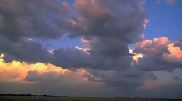 summer
days. Though thunderstorms are one of nature's most violent events, at
the end
of a sultry day, they mostly get a warm welcome: refreshing the air and
leaving a
reborn
earth behind. summer
days. Though thunderstorms are one of nature's most violent events, at
the end
of a sultry day, they mostly get a warm welcome: refreshing the air and
leaving a
reborn
earth behind.
These
storms develop pure out of heat and occur locally.
The
atmosphere simply awaits to moment that the temperature of
the air right above the ground
is so high that is rises very quickly, there's an updraft. Colder air,
falling
from above, takes its place, that's the downdraft. Rising air cools
down and the water
vapour condenses. Clouds will appear, those typical cumulus clouds,
which keep on growing, as long as the
surrounding air is cooler than the warm rising air.
As the cloud grows higher and higher the condensed water will freeze
into ice
crystals. The cumulonimbus with its anvil shape top arises.
Actually this is the normal process for showers to develop. These
showers will
grow out to thunderstorms when the differences in temperature between
the
various levels in the atmosphere is high enough. 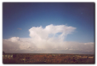
The updraft and the downdraft are so turbulent then, that the water and
ice
particles in the cloud are separated and split again and again. This
process builds
up electrical energy. At the ground the violent up- and downdraft are
felt as
gusts of wind.
The
updraft can become stronger when there's a jetstream at higher
altitude.
Jetstreams are strong winds at about 9 - 10 kilometer (30.000 - 33.000
feet)
high in the atmosphere, with a force of 65 mph or more.
These winds give an impulse to the updraft and to the connecting
downdraft: the thunderstorm becomes heavier.
These
jetstreams can also be the source of a band of thunderstorms not
developing by
heat. Its a law of nature that where the flow is high the pressure is
low. So
there's low pressure in these jetstreams which forces an uplift
of the air
at the ground, creating a up- and downdraft. Thunderstorms are
developing then,
even when the temperature is below 20° C.
Thunderstorms
are always accompanied by heavy rain or hail and wind
gusts. And lightening of course. The electric energy, built up
in the cloud,
discharges.In the cloud ice particles and hail whirl in the turbulence.
Hail becomes
heavier and falls down to the bottom of the cloud as ice particles are
taken by
the updraft. As they collide ice particles give their electrons to the
hail. So
the ice particles at the top of the cloud have a positive charge, as
the hail at
the bottom of the cloud has a negative charge. These electrons also
repel the
electrons near the ground, leaving the ground also positive.
And here's the scenario for electrical discharges - a flow of electrons
- from
bottom to the top within the cloud as well as from the cloud to the
earth below.
A lighting strike splices the air. In the most marvellous forms and
branching.
The lightening strike causes a rapid heating of the surrounding air,
that'll
suddenly expand with loud soundings: as thunder.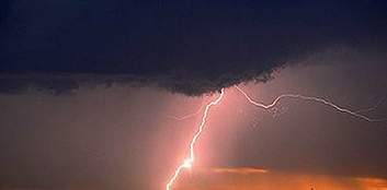
In
scientific literature thunderstorms are divided in three classes:
Ordinary
cells are single thunderstorms, developing by heat and short-lived.
Multicellular systems are more organized. In summertime they often
develop above
France -central Massive - where very warm and moist air from the
southeast bumps
into relatively dry and cold air from the west. A perfect hotbed for
those
complex thunderstorm systems.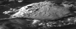
With a south to southeasterly flow they can easily reach Holland or the
south
east of the UK. Surviving even nights cooling down: they cover the warm
ground,
so that it stay warm, and radiate heat into the higher
atmosphere at the
top, so that the tops of the clouds stay cool. The difference in
temperatures,
needful for surviving, is guaranteed.
But also at the "prefronts" of a low these systems can grow.
Weather report Wednesday July 4 2001: heavy thunderstorms at the
British Isles
took people by surprise. Especially in West Scotland and
Wales In no time flooding
everywhere, brooklets turned into currents of mud. Many people had to
be
evacuated."
Supercells practically never occur in our regions; they bring alive
another phenomenon:
the tornado.
Sometimes tornado's do make their appearance:
witness the weather report august 21 2000: "This morning a sudden
tornado
visited East Anglia. Heavy thunderstorms brought so much hail that the
landscape
got a wintry character. No damage reports so far"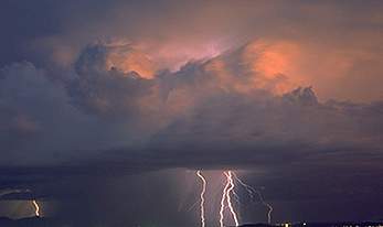
Thunderstorms
often give opportunity to the most wonderful pictures.
Try for yourself? You can find some information at:
www.nssl.noaa.gov/
|